Litratu:Aguijan ISS017-E-20419.JPG

Magåhet mineddong-ña(1,280 × 1,024 na pixel, mineddong atkibu: 79 KB, MIME klåsi: image/jpeg)

This file is from Wikimedia Commons and may be used by other projects. The description on its file description page there is shown below.

Sumaria

Description
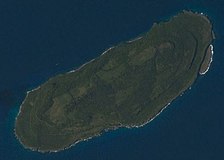
Polski: Wyspa Aguijan w archipalegu Marianów Północnych
English: Aguijan Island, one of the Northern Mariana Islands
Date
Source ISS017-E-20419
Author NASA
Other versions
Camera location14° 48′ 00″ N, 145° 36′ 00″ E Kartographer map based on OpenStreetMap.View this and other nearby images on: OpenStreetMapinfo
This image or video was catalogued by one of the centers of the United States National Aeronautics and Space Administration (NASA) under Photo ID: ISS017-E-20419.

This tag does not indicate the copyright status of the attached work. A normal copyright tag is still required. See Commons:Licensing.
Other languages:

Licensing

Public domain This file is in the public domain in the United States because it was solely created by NASA. NASA copyright policy states that "NASA material is not protected by copyright unless noted". (See Template:PD-USGov, NASA copyright policy page or JPL Image Use Policy.)
Warnings:

Captions

Add a one-line explanation of what this file represents

Items portrayed in this file

depicts English

inception English

21 Oktubre 2008

14°48'N, 145°36'E

media type English

image/jpeg

checksum English

4c8ce17de0bdc1d545df179910b311795818e900

determination method English: SHA-1 English

data size English

81,251 byte

height English

1,024 pixel

width English

1,280 pixel

Historian atkibu

Yemme' i fecha/ora para un li'e' i atkibu annai annok guihi na momentu.

Fecha/OraThumbnailMineddongMuna'sesetbiKomentu
pa'go18:58, 25 Febreru 2016Thumbnail for version as of 18:58, 25 Febreru 20161,280 × 1,024 (79 KB)SzczureqUser created page with UploadWizard

Tåya' na påhina siha umachetton yan este na atkibu.

Global file usage

The following other wikis use this file:

Metadata