Litratu:Northern Mariana Islands map.gif
Tåya' mas takhilo' na risolusion.
Northern_Mariana_Islands_map.gif (345 × 371 na pixel, mineddong atkibu: 24 KB, MIME klåsi: image/gif)
Sumaria
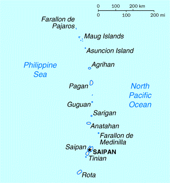
| Description | Map of the Northern Mariana Islands |
| Source | http://www.doi.gov/oia/Islandpages/cnmipage.htm |
| Author | United States Department of the Interior |
Licensing
| This image or media file contains material based on a work of a United States Department of the Interior employee, created as part of that person's official duties. As a work of the U.S. federal government, such work is in the public domain in the United States. See the Department of the Interior copyright policy for more information. |  |
Historian atkibu
Yemme' i fecha/ora para un li'e' i atkibu annai annok guihi na momentu.
| Fecha/Ora | Thumbnail | Mineddong | Muna'sesetbi | Komentu | |
|---|---|---|---|---|---|
| pa'go | 03:17, 18 Agosto 2010 | | 345 × 371 (24 KB) | Ras67 | cropped |
| 00:24, 17 Måyu 2008 |  | 351 × 377 (25 KB) | Scanlan | {{Information |Description=Map of the Northern Mariana Islands |Source=http://www.doi.gov/oia/Islandpages/cnmipage.htm |Date= |Author=United States Department of the Interior |Permission= |other_versions= }} [[Category:Maps of the Northern Marian |
Inachetton dokumento
Umachetton i sigiente na påhina yan este na atkibu:
Global file usage
The following other wikis use this file:
- Usage on af.wikipedia.org
- Usage on ar.wikipedia.org
- Usage on ast.wikipedia.org
- Usage on be-tarask.wikipedia.org
- Usage on bn.wikipedia.org
- Usage on cs.wikipedia.org
- Usage on cy.wikipedia.org
- Usage on da.wikipedia.org
- Usage on en.wikipedia.org
- Usage on es.wikipedia.org
- Usage on fa.wikipedia.org
- Usage on fr.wikipedia.org
- Usage on he.wikipedia.org
- Usage on id.wikipedia.org
- Usage on incubator.wikimedia.org
- Usage on io.wikipedia.org
- Usage on ja.wikipedia.org
- Usage on ka.wikipedia.org
- Usage on ml.wikipedia.org
- Usage on mr.wikipedia.org
- Usage on pt.wikipedia.org
- Usage on ru.wikipedia.org
- Usage on ta.wikipedia.org
- Usage on to.wikipedia.org
- Usage on tr.wiktionary.org
- Usage on tt.wikipedia.org
- Usage on uk.wikipedia.org